 |
Welcome to the Oregon GIS Framework Newsletter! Inside this issue you will find:
* the featured data set: school locations and education boundaries - 2015
* recent FIT activities and upcoming meetings
* changes to the Oregon Metadata Standard
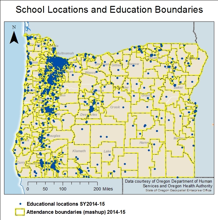
* an update on HB 2906 This newsletter is published up to four times a year by the Oregon Geospatial Enterprise Office. | The Oregon school locations and education boundaries (2015) data set was published in June 2014 by the Oregon Department of Human Services and Oregon Health Authority (DHS/OHA; Office of Forecasting, Research and Analysis). The downloadable geodatabase consists of five feature classes representing child care facilities, all school locations, the school property areas, as well as attendance boundaries for public and charter schools, and a second attendance boundary “mashup” of attendance boundaries for all schools and educational service districts. This is currently considered the most comprehensive and detailed educational dataset in the nation and is completely open source. Six years ago, the State’s foster care program, housed within DHS, wanted to identify the current school for a child entering into the foster program. At the time, school district boundaries existed, but breakdowns of the grade-level catchment or attendance areas did not. This data gap meant that a child’s address and grade level could not be used to identify her school. Part of the vision of the foster care program, as outlined in the Oregon Child and Family Service Plan (2015-2019) is to ensure that the services provided to foster children and families are culturally relevant and provided in communities. Maintaining a child’s attendance at a familiar school and its community is part of that vision for helping children succeed in school and beyond. It took DHS a year to compile attendance boundaries for each K-12 public school in every Oregon school district, verify features, and tie campus footprints to assessor tax lots (where possible). The effort allowed the agency to answer the original school attendance question, and it became clear that the geographies could be used to actualize other parts of the agency’s vision. For example, DHS used the data to institute a rule (OAR 333-008-0010) to separate medical marijuana dispensaries from schools by a 1,000-ft exclusionary zone. The data also enabled more informative analyses, such as mapping of poverty hotspots within the attendance area geographies. DHS values these data and devotes resources to ensure it is updated annually, at minimum. Continual update processes have not yet been accomplished but is an identified work area for the agency. DHS plans to expand the data by adding, for instance, building structural footprints and attributes to identify dedicated student instructional facilities within campuses. For more information, please contact Arron Heriford. Get a description and download these data. Time period for data on OSDL: 2014 - 2015 Want to know more? Contact Arron Heriford, Oregon Dept. of Human Services & Oregon Health Authority, ARRON.E.HERIFORD@dhsoha.state.or.us | The 21st Framework Forum took place on September 22, 2017 at Metro Regional Center, 600 NE Grand Ave., Portland, OR 97232-2736. Over 40 people attended the event which included a featured presentation by Christine Kendrick, PhD (City of Portland) on the topic of smart cities and implementing an open data model. The program also included updates from the Framework Implementation Team community on current work efforts, program developments, and more. The next Forum is planned for early March 2018 in the Roseburg area. If you can help with a meeting place and caterer, please contact Theresa Burcsu. The Framework Development Program for 2017-2019 wrapped up in September. Read about the projects selected for funding on the Framework Development Program webpage. The focus of the program this year was on the foundational data elements of the Framework -- those data elements that are the base data for Framework. While foundational data elements will also be the focus next biennium, there will be room for some projects that fall outside of this category. The Bioscience, Hydro, Preparedness, and Elevation FITs met earlier this year. Among the topics covered were the foundational data elements within each FIT. The Utilities FIT Power Lines Work Group also met regularly with the purposes of collecting power lines data use cases, information on data restrictions and security, and initiating work on a power lines data standard. The Land Use/Land Cover's Land Use Work Group met to review work on a statewide land use classification and map out the future of a land use data element. The Framework Metadata Work Group reconvened between August 2016 and June 2017 to discuss the Oregon Metadata Standard. The standard underwent minor revisions and was reviewed twice. Read more about the revisions below. The FIT Leads met several times in 2016 and 2017. The group identified a number of work tasks, including reviving efforts to clarify the process for identifying and incorporating data elements into Oregon's GIS Framework. A small group of FIT Leads came together to begin work on the identified tasks, and successfully drafted a definition for Framework elements that was proposed to and accepted by the full set of FIT leads. The group's work in 2016 and early 2017 work resulted in the release of the FY17-19 Framework Development Program request for proposals and the program's focal areas. The next FIT Leads regular meeting will take place in early February 2018 with a special meeting October 30, 2017. | Joint Preparedness and Hazards FIT meeting
November 7, 2017 - 9:30 to 11:30 AM
Marion County Public Works Bldg., Willamette Room
5155 Silverton Road NE, Salem, OR 97305 Elevation FIT meeting
mid-November
(Lead Jake Edwards will be in touch about meeting logistics, or reach out to him) Hydro FIT meeting
early January 2018
(Lead Bob Harmon will send out a Doodle at the end of October) FIT Leads
Special Meeting - October 30, 2017 - 10:30 to 12:00 PM - to discuss upcoming OGIC activities
Regular Meeting - early February 2018 (exact date and location TBD) | Oregon's Metadata Standard was incremented to version 2.04 in response to the need to discover the data steward in Framework data elements. Automated discovery of metadata elements helps geospatial data users find the data they are looking for and is a thing of the present. The Oregon Spatial Data Library, the Oregon Framework's primary data catalog and portal for non-imagery geospatial data, uses automated processes to build the records website visitors see. These records are built from the metadata elements of the geospatial data cataloged on the site. During the update of the Oregon Spatial Data Library in 2016, the steering group, also known as the Data Catalog Work Group, identified that entries for the data steward were not standardized and as a result, could not be automatically discovered from metadata records. To address this issue, the Oregon Metadata Standard was updated between August 2016 and June 2017 by the Metadata Work Group. The data steward should now be entered in the Publisher metadata element 8.8.2. The metadata tool or Oregon GIS Metadata Editor for ArcCatalog is now available from the Oregon Spatial Data Library and from the Framework standards webpage, under Metadata. The Metadata Editor is an importable ArcCatalog template that is customized for the Oregon Metadata Standard, currently version 2.04. After it has been imported and selected as the metadata template, a user will see fewer metadata element fields and will also see flags for incomplete metadata elements. The Metadata Editor is being phased into the process used by the Geospatial Enterprise Office to check metadata and other aspects of the data prior to cataloging in the Oregon Spatial Data Library. All data will be expected to pass the metadata test provided in the tool soon, with a target date of January 1, 2018. | House Bill 2906 became statute in the 2017 Oregon Legislative session. The Act established the Oregon Geographic Information Council within the office of the State Chief Information Officer and a fund into which moneys can be appropriated for the purposes described in the Act. The Act also specified membership, purposes, and powers of the multi-jurisdictional council. Among the first activities of the new council is the development of a funding model for data sharing under the Act to be submitted by July 2018 to meet deadlines for the 2019 Legislative session. In order to complete this model, FIT leads will be convening the theme work groups to collect information and data about the costs related to Framework data elements and their completion. Other activities of the new council include development of a council charter and a review of Oregon's GIS Framework. The new Oregon Geographic Information Council is expected to meet for the first time this fall. | FGDC published a white paper earlier this year that briefly describes the history of FGDC standards. FGDC endorsed ISO 19115-1:2014 Geographic information Metadata – Part 1: Fundamentals and ISO 19157:2013 Geographic information - Data Quality. The FGDC ISO Forum and Metadata Working Group has been working to make the transition to the ISO standard go smoothly with regular discussions and presentations from participating federal agencies. For example, NOAA is working to implement the new standard and gave a presentation at the February 15, 2017, FGDC ISO Forum and Metadata Working Group meeting. The group meets monthly on the second Wednesday of the month. Did you know that the Oregon State Library has a collection of digital maps? Check out maps from the library. GEO, in partnership with GPL (GIS Program Leads), has initiated a conversation with the library about this collection. There have been several changes in the leadership of FIT themes since the last newsletter was published. Jake Edwards (Oregon Department of Geology and Mineral Industries) has replaced Jacob Macdonald (Army Corps of Engineers) as the Elevation FIT lead. Jake E. also coordinates the Oregon Lidar Consortium (OLC). Steve Lucker, formerly of Oregon’s Department of Land Conservation and Development, has stepped down from the Hazards FIT leader position. Replacing him is Ed Flick, Marion County Emergency Manager, who was endorsed by the Oregon Geographic Information Council (OGIC) in March. Ed brings considerable experience from his work with the National Intelligence Priorities Framework to the Hazards FIT and Oregon’s GIS Framework community. Please welcome Jake and Ed to the Framework Implementation Team when you have the opportunity. | As the not-so-new-now Framework Coordinator, I follow in the footsteps of very qualified and capable people who are well known and friends to many of you. It is clear that they have set down a path with success in mind, and that the GIS community has, through its collective hard work and commitment, benefited in the form of data standards and standardized data sets, data sharing through a variety of online websites and services, and stewardship. It is also clear that as technologies change and new challenges surface, the program must continue to grow and adapt, and is equipped to do so as a result of the many minds involved in the program. One of my goals is to effectively facilitate the program's growth and development using the collaborative approach that is central to the program as we know it now. Theresa Burcsu
Oregon Framework Coordinator | Want to see your work featured in the newsletter? Send an email with a short description of your story to Theresa Burcsu, theresa.burcsu@oregon.gov! | You have received this email because you are subscribed to one or more of the Framework email distribution lists. | | |

